Satellite radar and underground scans have uncovered a 26th Dynasty structure at Buto, built on a sand foundation that helped protect it from unstable delta clay.
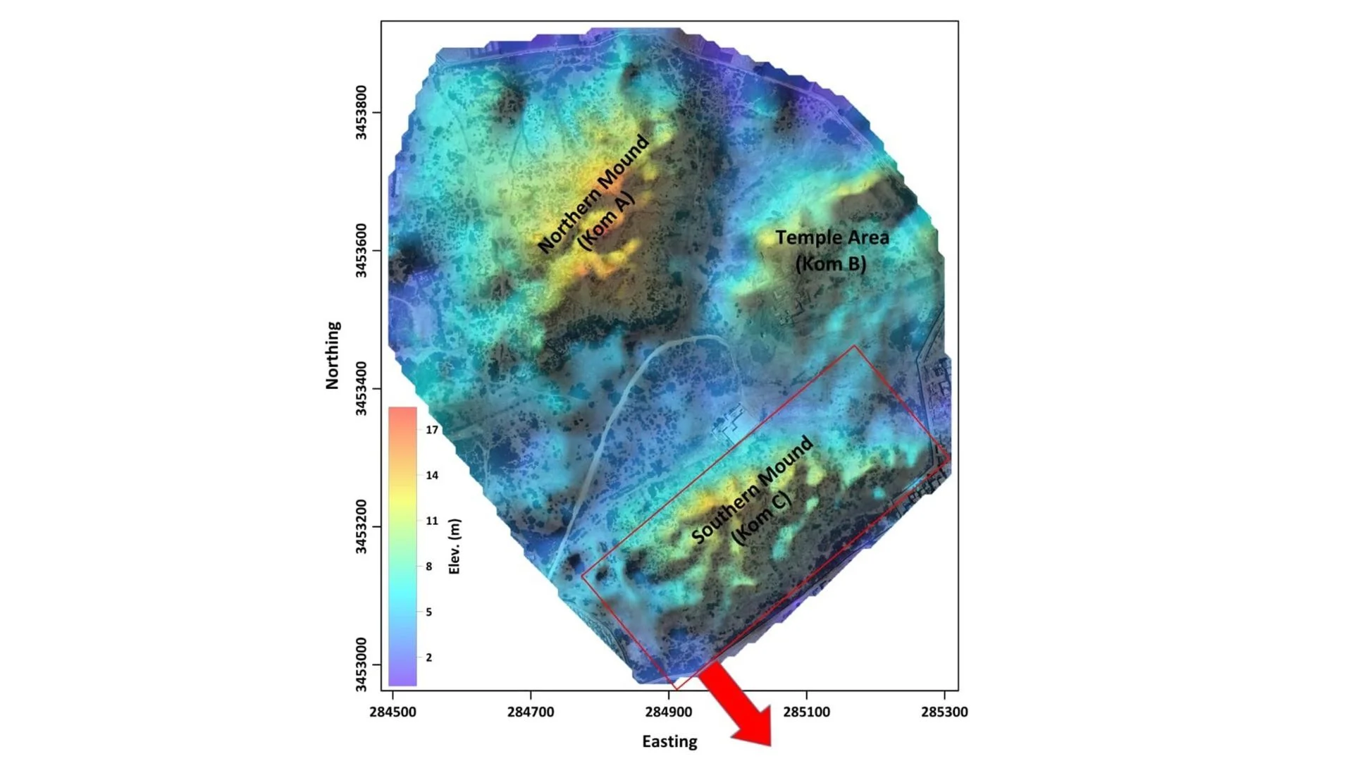
The most revealing feature of a newly mapped monument beneath ancient Buto may be the material its builders put underneath it. More than 2,500 years ago, they laid thick mudbrick walls on a deep bed of clean sand, a foundation that appears to have helped the structure withstand the Nile Delta’s waterlogged, shifting ground.
The discovery combines a large buried building with evidence of practical engineering and religious activity. Researchers used satellite radar and underground electrical surveys to investigate Kom C, a mound at Tell el-Fara'in in Egypt’s northwestern Nile Delta. Their results, published in March in Acta Geophysica, point to a monumental structure from Egypt’s 26th Dynasty, or Saite period, which lasted from 688 to 525 B.C.
Radar identified a buried footprint
Buto was a sacred city associated with Wadjet, the cobra goddess of Lower Egypt, and ranked among the region’s significant religious centers. Its remains lie beneath a broad mound of accumulated settlements. Archaeologists have long studied the upper layers, uncovering evidence from the Ptolemaic dynasty (305 to 30 B.C.) and the Roman era (30 B.C. to A.D. 395). At Kom C, however, the water table made deeper excavation difficult. Earlier work reached those later periods before groundwater blocked access to older deposits.
To search below the surface without opening a large excavation, the team first examined radar data from the European Space Agency’s Sentinel-1 satellite. The system sends microwave pulses toward Earth and records their return. Differences in moisture, elevation and reflectivity can help identify features hidden beneath the ground.
The satellite images revealed an oval-shaped anomaly under Kom C, measuring about 420 feet long and 203 feet wide (128 by 62 meters). The dimensions suggest a substantial complex. The radar result gave the researchers a target to investigate on the ground, while keeping the initial survey noninvasive.
Scans trace the structure and its foundation
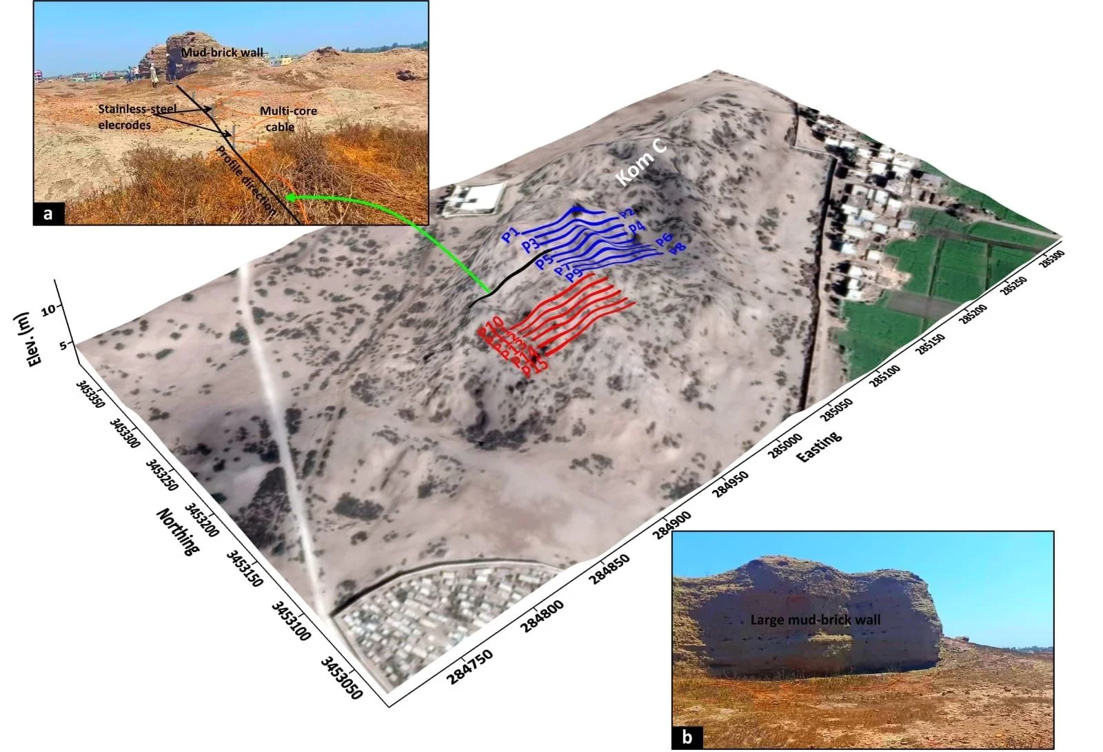
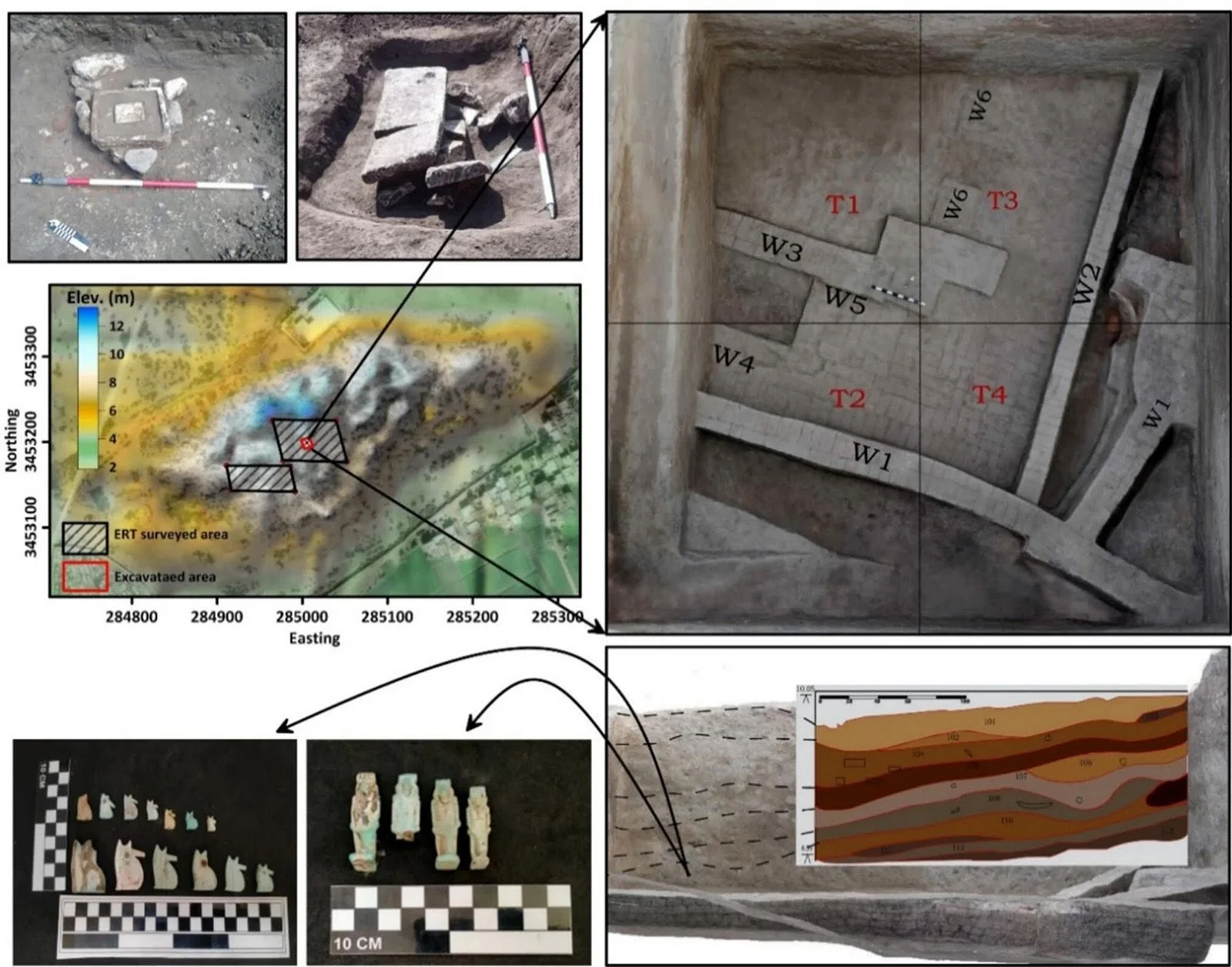
The team followed up with 15 parallel lines of electrical resistivity tomography (ERT) across roughly 58,100 square feet (5,400 square meters). ERT passes electrical current through the ground and measures how the subsurface resists it. Those measurements produce profiles that can distinguish buried materials and structures.
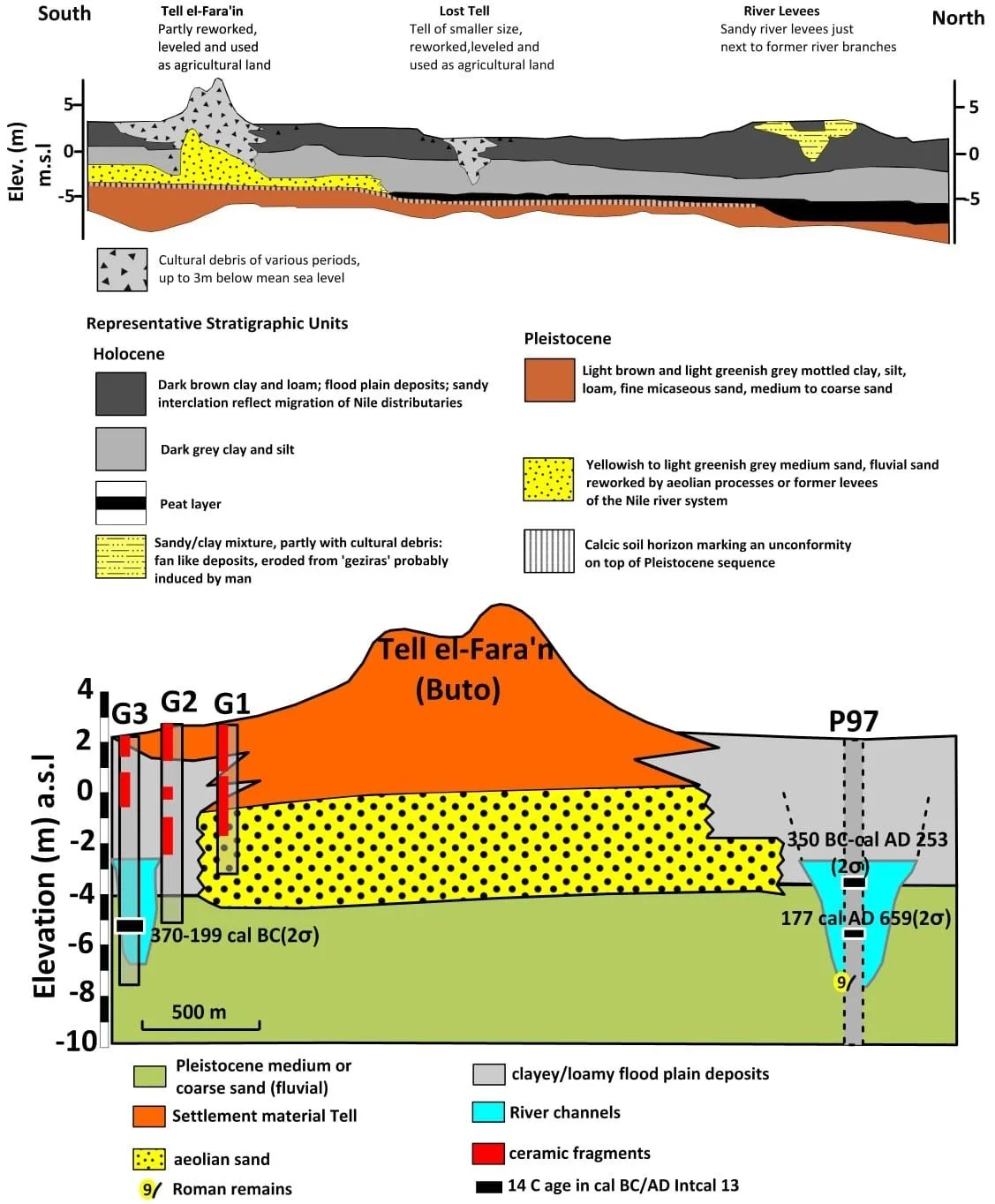
The scans show a sequence of occupation. In the upper 10 feet (3 meters), researchers detected scattered Ptolemaic and Roman debris, including displaced mudbricks, pottery fragments and broken limestone. The mix is consistent with a site that remained in use and was repeatedly rebuilt. Later occupants appear to have taken apart older buildings and reused their materials, leaving fragments spread through the upper deposits.
Between about 10 and 20 feet (3 and 6 meters) down, the survey identified a large mudbrick structure dating to the Saite period. Researchers based the dating on the structure’s archaeological layer, the form of its bricks and associated pottery, with carbon-14 dating applied to organic material from the same context. The building’s purpose remains unresolved. It could have been a tomb, a priestly residence or a religious shrine, the researchers wrote.
Below the building, at a depth of roughly 20 to 23 feet (6 to 7 meters), the team found a thick layer of clean sand. That deposit is central to the study’s interpretation of how the walls were built to last.
Nile Delta clay can absorb water, swell, then shrink and shift as it dries. That movement can destabilize heavy structures. A bed of sand beneath the mudbrick would have helped distribute the building’s weight and drain water away from its base. It may also have limited the movement of the surrounding clay and reduced groundwater’s ability to rise into the bricks, where moisture could weaken them.
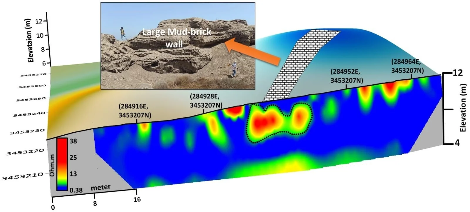
“By combining satellite radar with deep ERT profiles, we didn't just map the walls of this massive Saite-era structure — we were also able to analyze the subsurface layers,” study co-author Abdelaziz Elfadaly, an associate research professor at Egypt’s National Authority for Remote Sensing and Space Sciences, told Live Science. He said the clean sand layer helps explain how the building endured the area’s high water table and unstable clay.
Objects offer clues to religious use
A small excavation trench, approximately 3 by 3 feet (10 by 10 meters) and 20 to 23 feet (6 to 7 meters) deep, confirmed that thick mudbrick walls rested on the sand. Nearby finds add evidence that the complex had a sacred function, though they don’t settle the building’s precise role.
Among the objects were ushabti and shawabti figurines, small figures commonly placed in tombs to serve the deceased in the afterlife. Researchers also found a limestone altar with carved channels containing dried material consistent with animal blood, a possible sign of offerings. A faience baboon figurine was another notable find. Baboons were associated with Thoth, the god of wisdom.
The building also fits the wider history of the Saite period. After eras of Libyan and Assyrian rule, Egyptian pharaohs regained the throne and invested in restoring religious centers, particularly in the Nile Delta. The dynasty ruled from nearby Sais. Supporting Buto, a city closely tied to Lower Egyptian identity, would have reinforced the region’s religious importance and the rulers’ connection to it.
Hussein Bassir, director of the Antiquities Museum at Bibliotheca Alexandrina, who did not take part in the study, told Live Science that a monument of this scale reflects the Saite rulers’ interest in the Delta. He also pointed to the sand foundation as evidence of deliberate planning: “The ancient builders profoundly understood their environment.”
Further surveys could clarify the site
The findings show what a combination of satellite observation and ground-based scanning can reveal where excavation is constrained by groundwater. Sentinel-1 helped locate the buried footprint; ERT then mapped the structure and the layers beneath it. A limited trench provided physical confirmation of the walls and foundation.
The team plans to return with electrical resistivity surveys spaced farther apart to investigate deeper deposits. Specialists in ancient plants and geological change are also expected to help reconstruct the setting around Buto when the building was constructed. That work could clarify how the site changed over time and how its builders adapted to the Delta’s difficult ground.
For now, the strongest conclusion is both architectural and environmental: Saite builders raised a large mudbrick complex at a major religious center and placed it on a sand bed that appears suited to the local soil and water conditions. Further work may reveal the building’s purpose and whether the same engineering approach appears elsewhere in Buto.
Discussion
Sign in to join the discussion.