A stunning satellite image reveals a swirling cloud "street" and a long sediment plume near Jeju Island, sparked by unique atmospheric conditions.
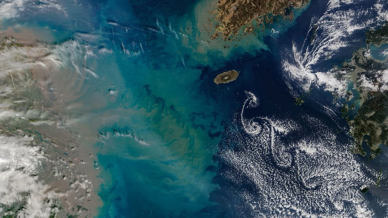
This breathtaking satellite image showcases a dramatic interplay between swirling clouds and a vibrant sediment plume, situated in the waters of the East China Sea near Jeju Island, South Korea. The photo, captured by NASA's Terra satellite on February 19, 2026, highlights the fascinating phenomena associated with this volcanic region.
The Science Behind the Clouds
The clouds depicted in the photo are known as a Kármán vortex street, formed as winds navigate around Hallasan, a shield volcano that towers 6,400 feet (1,950 meters) above sea level. Situated about 60 miles (100 kilometers) south of the Korean Peninsula, Hallasan stands between China's Jiangsu province to the west and Japan's Kyushu island to the east. When winds reach speeds between 11 and 34 mph (18 to 55 km/h), they create counter-rotating vortices on the volcano's leeward side. This leads to the unique cloud formations visible in this image. These swirling patterns trace a length of about 230 miles (370 km) across the sky, showcasing nature's ability to create dramatic visual displays with merely wind and elevation.
The Kármán vortex street phenomena isn't just an atmospheric curiosity; it also illustrates the complex interactions between geography and climatology. When strong winds encounter a significant landform like Hallasan, they can't simply flow straight over. Instead, they split into rotating currents, generating the iconic patterns here. This is more significant than it looks. Such vivid cloud designs can inform scientists about prevailing wind patterns, climate conditions, and even potential weather changes, making these satellite images important for meteorological studies.
The Plume Breakdown
In addition to the cloud formations, the image reveals a thick brownish curtain of sediment extending along China's eastern coast, notably near Shanghai. This sediment, predominantly discharged by the Yangtze River, creates a consistent visibility of similar scenes from space year-round. However, what stands out in this particular photograph is a distinct yellow and green sediment plume that stretches approximately 270 miles (430 km) from the coast and seems to almost intertwine with the vortices.
Researchers attribute this elongated, pale plume to several factors: increased turbulence in the Yangtze due to elevated rainfall, seasonal current variations, and vertical ocean mixing during the winter months. Such phenomena are not uncommon near islands with significant peaks, producing spectacle often witnessed from space. Heavy rainfall, particularly during monsoon seasons, tends to increase sediment flow into the ocean, enriching the waters and affecting marine ecosystems. This sediment is not just an aesthetic element; it can impact local fishing industries and the health of marine life. The interplay of these factors is indicative of a broader environmental narrative that is often overlooked.
Rare Simultaneity of Events
While von Kármán vortices are a familiar sight around archipelagos featuring towering mountains, data suggests that simultaneous occurrences of such oceanic and atmospheric events remain uncommon. Historical comparisons include vortex formations off Mexico's Guadalupe Island and Spain's Canary Islands. Observing both a sediment plume and Kármán vortices in one frame is indeed a rare treat for Earth observation enthusiasts. Such dual occurrences provide a window into the complex ecosystems that exist in these areas.
Combining atmospheric and oceanic phenomena in a single satellite image can yield insights into broader climatic patterns. For those studying climate change or environmental shifts, instances like these can serve as valuable case studies. They demonstrate how interconnected our systems are, offering a chance to analyze implications for weather, marine health, and even local economies that depend on fishing and tourism. The rarity of such events makes them even more precious for scientific documentation.
Jeju Island's Rich History
Jeju Island, formed from submarine volcanic activity around two million years ago, has been home to the Indigenous Jeju people for roughly 8,000 years. Recent studies highlight unique genetic mutations in the local population that may aid the famed Jeju Haenyeo, or "women of the sea," in their skilled free diving practices without specialized gear. Hallasan, also known as Mount Halla, is recognized as Korea’s tallest mountain and is technically classified as an active volcano, though its last eruption took place in A.D. 1007, according to the Smithsonian Institution's Global Volcanism Program.
Understanding Jeju's geological and cultural significance paints a fuller picture of how different environmental and human histories intertwine. The extensive system of lava tubes formed by Hallasan's past activity is regarded as among the finest globally, according to UNESCO, adding to the island’s geological intrigue. This geological uniqueness is also intertwined with the island's cultural practices, such as the Haenyeo's tradition of free diving for seafood, which speaks to the intimate relationship between the community and its surrounding environment.
Future Implications and Outlook
If you're working in this space, the relevance of this satellite imagery extends beyond mere beauty. With ongoing discussions about climate change, such phenomena trigger inquiries into changing weather patterns and sediment shifts due to increased rainfall and shifting ocean currents. Researchers are tasked with understanding how these changes can impact local environments and economies.
This moment captured in time not only reveals natural beauty but also calls attention to the urgent environmental narratives unfolding in real-time. Monitoring sediment flows and atmospheric conditions offers implications for predicting future climate scenarios. The significance of these occurrences could reshape how scientists view ecosystem interactions and environmental planning. As research advances, the hope is that tools like satellite imagery will continue to provide critical data for understanding our planet’s shifting conditions.
Discover More
For those interested in exploring more stunning visuals from Earth’s orbit, check out NASA's Earth from space series.
Discussion
Sign in to join the discussion.